by J. D. Jacobs and R. J. Gibson
Nature Newfoundland and Labrador
“(In future planning and development) it will be necessary to keep in mind the location of land uses in relation to: Protecting waterways, wetlands, natural areas, and forested lands that provide animal and plant habitats, foster healthy ecosystems, and control the volume of stormwater.” St. John’s Municipal Plan Review 2012: Background Report (p. 15)
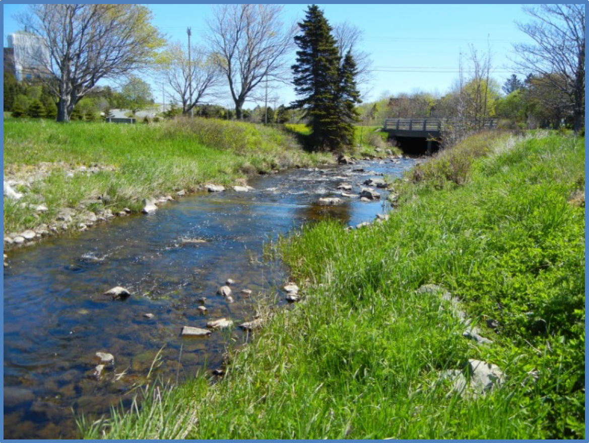
A stormwater assessment and proposed flood control plan for the Rennies River catchment is the subject of a report submitted in April 2014 to the City of St. John’s by CBCL Consulting Engineers.
What it is not:
This is not a hydrological analysis aimed at protecting the ecological integrity of Long Pond, Rennies River and its tributaries under further urban development and a changing climate. In keeping with 2012 Municipal Plan Review, such a study should be done in parallel with this one.
What it is:
It is an analysis that uses past extreme stormwater events (e.g. Hurricane Gabrielle 2001) as a basis for modelling peak flows and flooding in the Rennies River catchment area, taking into consideration expected future development within the watershed, as well as projected changes in precipitation due to climate change. It proposes “stormwater detention” measures to address future flood conditions, including a weir at the outlet of Long Pond. Floodplain area and flood hazard maps are presented for projected 20-year and 100-year events under “existing “ and “future” conditions, as well as future conditions with the recommended “improvements”.
The following comments are based on a review of the scenarios presented in the report.
- Flooding has always occurred as a natural process in the Rennies River system and will inevitably continue to occur in the future. These natural processes, along with considerable impacts from human activities, have had significant effects on aquatic life, stream beds, wetlands, and riparian habitat. However, as a result of conservation efforts by many citizens and public officials, the Rennies River system remains in relatively good condition. Question: Can new efforts at mitigating the effects of extreme flood events on downstream residents be carried out without reversing the gains that have been made toward restoring the integrity of the natural river system?
- Using the 100-year flood as the standard for comparison, the analysis shows that there will be only partial flood mitigation along the Rennies River with the proposed weir and other control measures. The principal difference is significantly reduced flooding in the recreational grounds between Kings Bridge Rd and Portugal Cove Rd. Question: Could those floodprone areas become designated areas of enhanced detention during flooding, with appropriate restrictions on land use there?
- With the proposed installation of a weir at its outlet, the 100-year flood will raise the level of Long Pond by 2.7 m. The non-flood level will also be increased by an unspecified amount. This increase in mean level and seasonal fluctuations in that level will negatively impact the extensive wetlands at the west end as well as the shoreline generally. Question: How extensive will these impacts be and how will they affect the ecological, recreational, and aesthetic values of Long Pond?
- Some areas upstream of Long Pond also show reduced flooding with the controls in place. However, headwaters areas further upstream show no change in detention. Questions: Do the proposed controls increase the rate of flow into Long Pond? Can more detention be created in headwaters areas and, if so, would this reduce the flow to Long Pond and further downstream?
- The “future” scenarios show a substantial increase in the amount of impervious area within the watershed, and assume an imperviousness factor of 80 % (p. 19 Table 6.1). Question: Have all options for maintaining a lower degree of imperviousness through “green” planning practices been considered, such as limiting building and parking area size, mandatory green space retention, and improved infiltration and natural cover?
From the report, p39.
Location 3 – Outlet of Long Pond
In terms of overall impact on the study area, the most significant flood protection improvement is the weir located at the east end of Long Pond, which is noted as location 3 on Figure 10-1 [not available].
Constructing a weir at this location will result in water being temporarily stored in Long Pond during a storm event and released at a lower flow rate than the flow rate would be without the weir in place. Due to the increased storage capacity, the level of Long Pond would increase for a short period of time during a storm and return to its normal level a short time after the end of a storm. The overall increase in the storage capacity of Long Pond with the weir in place is in the order of 160,000 m3 increase to approximately 55.7 m during the future 1:100 AEP flood event with the weir in place. The normal water level of Long Pond is approximately 53 m and will increase to approximately 55.7 m during the future 1:100 AEP flood event with the weir in place.
The major benefit of the weir is that the peak flows downstream of Long Pond will be reduced, resulting in reduced costs associated with the implementation of flood control options at locations downstream. For example, berms or walls proposed at locations downstream of Long Pond will not be as high with the weir in place because the peak flows will be reduced. In order to realize these benefits, the weir must be constructed before the other downstream improvements. A preliminary design of the weir is presented on Figures 10-2 and 10-3 [not available]. Note that an opening in the weir will provide for the passage of fish.
Composite of projected 100-year flood mapping with and without flood control improvements
(Source: 2014 Flood control report)
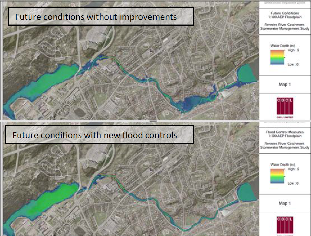
100-year event floodplain area comparison
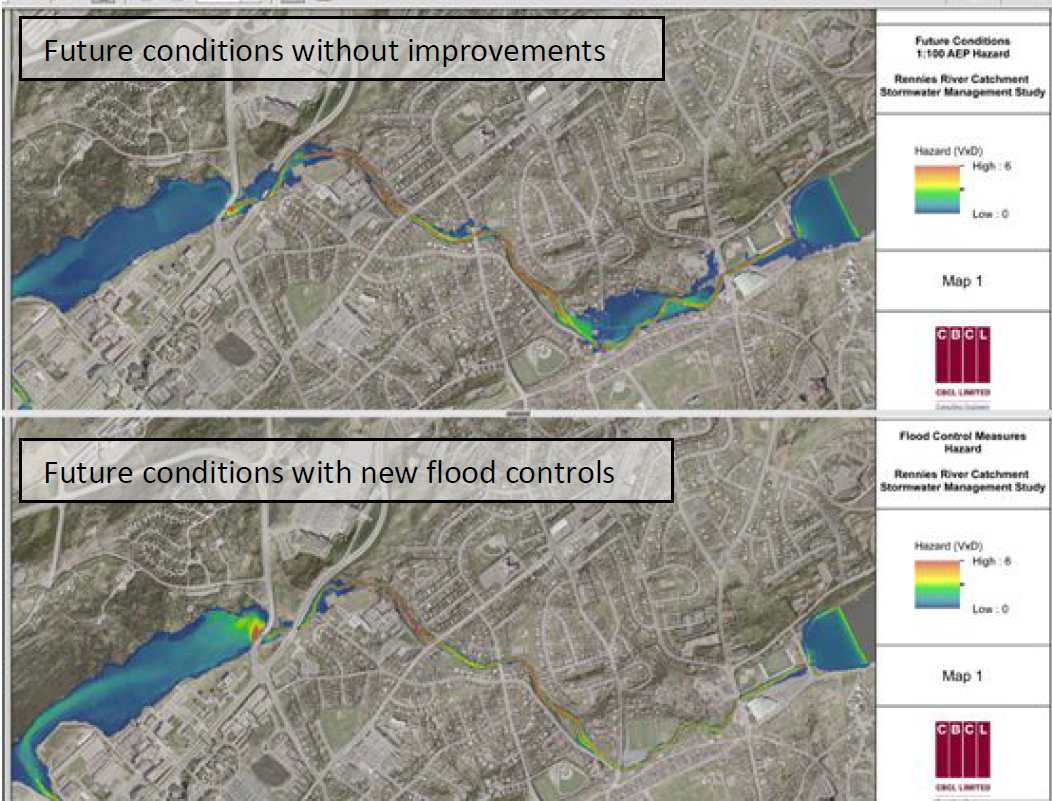
100-year event flood-hazard comparison
Implications for Fish Habitat – R. J. Gibson
It is important that flooding of properties along Rennies River, and upstream of Long Pond be controlled. However, my major concern is that the primary priority is for a weir at the outlet of Long Pond. Weirs and dams have negative effects on river ecosystems, both upstream and down. Nutrient cycling and transport is interrupted, so that downstream general productivity is decreased. Dams may interrupt sediment transport, resulting in substrate ‘armouring’ downstream, but since this is at the outlet of a lake it should not be a problem here. However, a problem is interference with fish migration. The weir is designed to have a fishway. However, not all fish use a fishway. Just downstream of the outlet of Long Pond is an important gravel bed. Here in the fall adult trout from Long Pond migrate to spawn, later returning to the lake. Juveniles rear in the river for a year or two before migrating into the lake. Small fish, which includes young of resident brown trout, sea trout, and recently salmon, move up and downstream. They may find the fishway a barrier. I have to admit, without seeing the design, I don’t know how this proposed weir would work. Its purpose is to hold back high water during flooding events, so that to work it would have to have some device which comes into action during such times. It is described as a 25m long weir. If it is like the weir at the outlet of Quidi Vidi Lake, water flows over the top, but at high flows the discharge is not decreased, and discharge downstream is the same as upstream. Natural ranges in discharge affect stream morphology. Pools and riffles are dependent on high and low water. During high water events meanders are formed, pools are scoured out and riffles are deposition areas. In low water riffles are eroding areas and pools deposition areas. This diversity is important for invertebrate and fish life history habitats. Presumably ranges in discharge without damage to adjacent properties would still occur. To be useful this proposed weir would have to have a device to change relative flows during flooding events. Another problem with a weir is that during warm weather only the surface warm water of the lake is discharged over the weir down the river. Prolonged increases in water temperature reduces dissolved oxygen in the water, possibly killing fish, and high water temperature itself may become lethal for salmonids. In general a weir would have negative effects on Rennies River.
Depending on design of the weir, if Long Pond were impounded, there would be negative effects on littoral vegetation and the marshlands, and phytoplankton would increase. Such was the result in Lake Winnipeg when the outlet was impounded with a hydroelectric dam. Marshlands, including important bird habitats, were lost, and phytoplankton and algae increased, making beaches unsuitable for recreation.
The increase in flooding is due to poor planning upstream in previous years. A weir would do nothing to alleviate the present flooding damage upstream from Long Pond. “The overall increase in the storage capacity of Long Pond with the weir in place is in order of 160,000 m3 high floods would increase from 53 m to 55.7 m. I believe to avoid the negative effects of a weir on Rennies River and Long Pond efforts be made instead to construct holding ponds and wetlands upstream to control rates of discharge. This would benefit the flooding hazards upstream of Long Pond and be better for fish productivity. ‘Flashy’ rivers are less productive than those with more stable discharge.
“Channel widening and deepening” is proposed (p.38). Also “approximately 4000 m2 of the river banks need to be rehabilitated”. If channels are changed will fish habitat be restored for the different life history stages, such as pools and riffles, with boulder clusters and coarse gravel in riffles for spawning? It is stated in several places that there would be “loss of mature trees along the river banks”. It is well known that riparian vegetation is necessary to provide shade for cover for fish, keeping water cool for salmonids, providing sources of allochthonous food for invertebrates, filtering nutrients and sediments from outside the river, habitat for birds and other wildlife etc. Will the banks be revegetated, and who would be responsible for this?
Walls to prevent erosion are suggested. Depending on how these are constructed these can be damaging to stream ecology. Natural vegetated banks allow percolation of water during high flows out of the river, ameliorating flooding, and drain into the river during low flows (hyporheic water flow). Hyporheic habitats are also important for rearing of many aquatic invertebrates, and upwelling currents can be useful for trout at spawning sites.
It is suggested that sediment deposition upstream of culverts and bridges be periodically be removed (p.64). These riffle areas are often useful spawning areas. For example such a gravel bed built up above the bridge on Portugal Cove road. We used to watch hundreds of trout spawning here. This riffle was removed by the city to alleviate flooding, but it was a loss of fish habitat. It would be more sense to widen culverts and bridges, so that water is not slowed with deposition of sediments upstream of these constructions.
Precast structural sections to replace a bridge at O’Leary Avenue bridge is recommended (p.41). Some of these pre-cast structures can be barriers to upstream migration of fish, e.g. culvert no 10 at New Gushue Ramp 1, and culvert no 12 at North on Kelsey (Yellow Marsh). The latter also illustrates the unfortunately standard way of having drains discharging directly into the river rather than draining through vegetation at the side. Culverts should have the natural depth of the river with coarse substrate at the bottom, usually ignored, resulting in blockage to upstream fish migration. DFO has published adequate guidelines, to enforce proper conservation of fish habitat, usually ignored. Also DFO has clear regulations to conserve fish habitats, but, judging from previous experience, unfortunately not enforced with the city rivers. We should try and persuade city authorities to include ecological input into any works involving the city rivers. Usually nature does a more efficient and cheaper job than mere engineering works, but engineering solutions seem to be preferred, which often destroy nature.
Since the present flooding plans could cause severe negative ecological effects on this important city heritage, there should be an Environmental Impact Study, with suggestions as how to conserve the natural attributes of the system. There need to be before and after biological studies, and if there is loss of fish habitat, how this will be compensated.